
NWS Cleveland and Wilmington- Winter Briefings Updated
WILMINGTON
Good Afternoon Partners:
An updated weather briefing is available here, for wind, cold and snow threat this evening/tonight into the Christmas holiday weekend. Briefing graphics update automatically, text is static until the next briefing update.
For questions, or location specific weather support needs, contact us at 937-383-0623 or spotreport.iln@noaa.gov.
Thank you.
NWS Wilmington OH
CLEVELAND
Hello partners,
Here is our latest briefing regarding the upcoming winter storm and Arctic air outbreak.
What has changed:
- A Wind Chill Warning remains in effect for the entire area from 4 AM Friday to 10 AM Saturday.
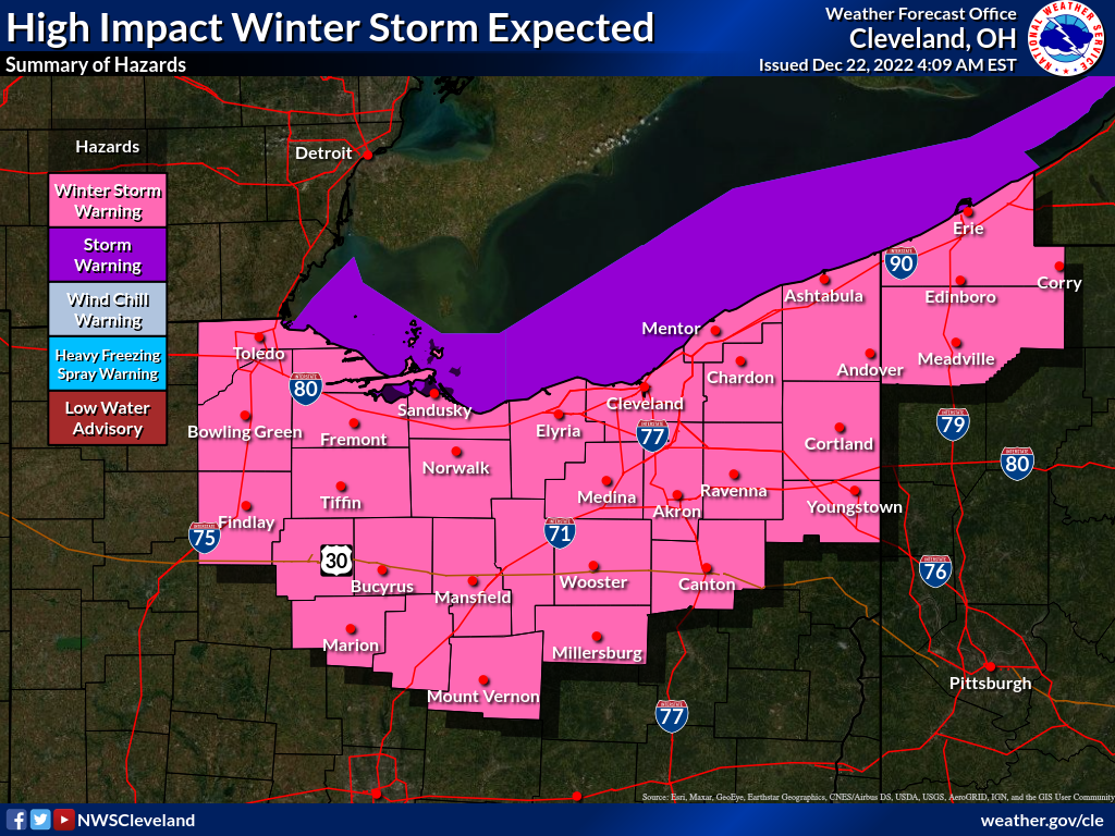
- The Winter Storm Warning remains in effect all counties of the NWS Cleveland area of responsibility.
There were minor forecast timing changes to the strong wind gusts, snowfall amounts, and minimum wind chill values. However, these changes will not change the hazardous impacts across the area.
What to expect:
- An Arctic cold front will cross the area early Friday morning…Widespread wind gusts of 50-55 mph, with wind gusts of 60-65 mph across Northwest Ohio and immediate lakeshore areas, will follow the front. Widespread wind damage is expected. Temperatures drop 30 degrees in a few hours for a likely flash freeze. Rain changes quickly to snow behind the front. A quick 2-3” of snow accumulation and very poor visibility in falling/blowing snow are expected Friday morning. This will be the most hazardous travel period.
- A multi-hazard winter storm…Impacts will begin tonight and persist through at least Saturday with a combination of significant winds, extremely cold temperatures, snow, blowing snow, and a flash freeze.
- Prolonged extreme cold…Some areas will have temperatures remain in the single digits for at least 48 hours Friday morning into Christmas morning. Frigid wind chills of -25°F to -30°F are expected Friday morning through Saturday morning.
- Additional snow…Additional snow amounts possible through Sunday in lake effect snow, with the most significant totals along/near the lakeshore of NE OH/NW PA.