
The Role of a Weather Spotter
FREE DOWNLOAD: NWS Wilmington Ohio 2024 Spotter Guide
FREE DOWNLOAD: Cloud Chart

The National Weather Service (NWS) Office in Wilmington uses Doppler radar and satellites imagery as its primary tools to detect severe weather. However, the most important tool for observing thunderstorms is the trained eye of the storm spotter. Doppler radar gives indications of air motions inside a storm but does not show the winds at ground level. It is impossible for any radar to detect every severe weather event in its coverage area, and radar occasionally suggests severe weather when, in fact, none is present.
As a trained spotter, you perform an invaluable service for the NWS. Your real-time observations of tornadoes, hail, wind, and significant cloud formations provide important information for severe weather detection and verification. By reporting your observations, you are assisting the meteorologist at Wilmington in their warning decisions and enabling the NWS to fulfill its mission of protecting life and property. You are helping to provide the citizens of your community life-saving information.
Background and Safety Tips
The NWS in Wilmington does not recommend chasing storms. Their goal has been to have enough storm spotters in each county to relay frequent, reliable information from the safety of their homes directly to their office. They issue severe warnings for 52 counties across southeast and east-central Indiana, Northern Kentucky, and Central and Southeast Ohio. They have over 5000 spotters, but the “per county” number of spotters does vary considerably. Of course, there are more spotters in the metropolitan areas of Cincinnati, Dayton, and Columbus.
NOAA Weather Radio Frequencies
Cridersville, OH (162.400 MHz)
Miamisburg, OH (162.475 MHz)
Columbus, OH (162.550 MHz)
Covington, KY (162.550 Mhz)
Otway, OH (162.525 MHz)
Owenton, KY (162.450 MHz)
Maysville, KY (162.425 MHz)
Richmond, IN (162.500 MHz)
Chillicothe, OH (162.500 MHz)
Skywarn Amateur Radio Section NET Frequencies
Dayton (W8OK): 146.640 MHz (South), 146.835 MHz (North)
Cincinnati (W8NWS): 146.880 MHz, 147.375 MHz (Owen, Grant, Pendleton)
Columbus (N8WX): 146.760 MHz
West Union: 147.000 MHz
Reporting Information
Method 1: Call (800) 899-2748 (Unlisted number for severe weather reports ONLY!) For general information, call (937) 383-0031 or e-mail iln.webmaster@noaa.gov.
Method 2: Report to HAM Radio Network NETS, ie. Fairfield County ARES Weather Spotter NET during severe weather on the 146.70 Fairfield County ARES Repeater. PL TONE 94.8Hz.
Method 3: Report on Social Media
Method 4: To submit detailed descriptions of damage, including pictures, please post to their facebook page, X account, or e-mail spotreport.iln@noaa.gov.
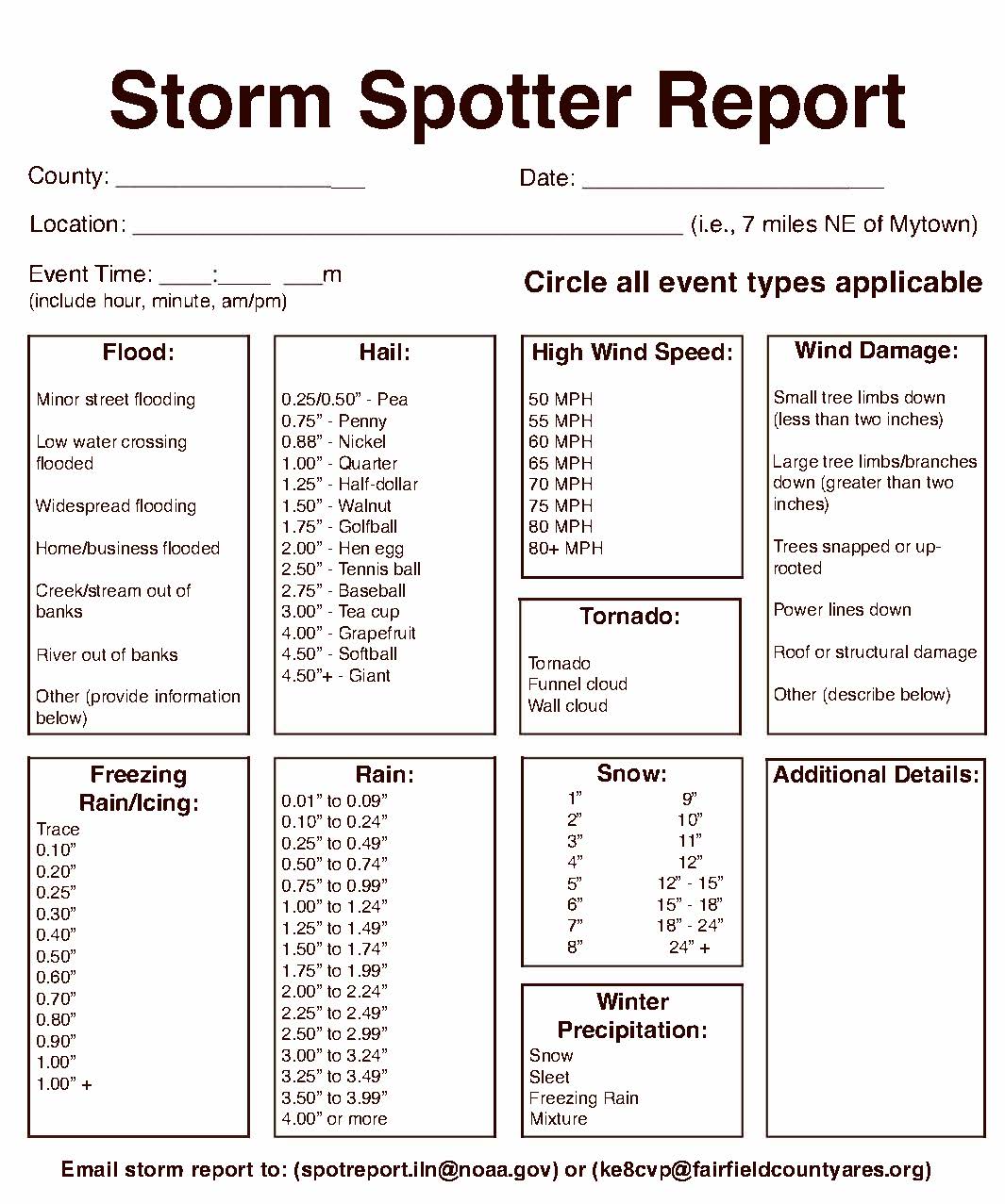
Download: Storm Spotter Report

Significant or Severe Weather
- Tornadoes
- Funnel clouds
- Wall Clouds
- Persistent rotation in clouds
- Hail ½ inch in diameter or larger
- Trees or multiple large limbs downed
- Structural damage to homes or businesses
- One inch or more of rain in 1 hour
Any Flash Flooding
- Flooding that results in evacuations
- High water rescues from roofs/trees
- Rushing water across roadways
- Water entering homes (not just basements)
Any Urban and/or Small Stream Flooding
- Roads closed or impassable due to high water
- Small streams overflowing their banks
Report the Following Winter Weather
- One inch or more of snow in 1 hour
- At least one measurement during an event
- Storm total at the end of an event
- Any freezing rain or freezing drizzle
- Any thunder or lightning associated with winter precipitation
How Do You Submit a Report?
- Time: Exact time and duration of the event
- Event: Specific description of the event
- Location: Exact location of weather event (include references to nearby cities, cross streets, or Lat/Lon coordinates)